Scallops
Tipa (also pure or tupa), Kuakua
Pecten novaezelandiaeAlso known as New Zealand scallop
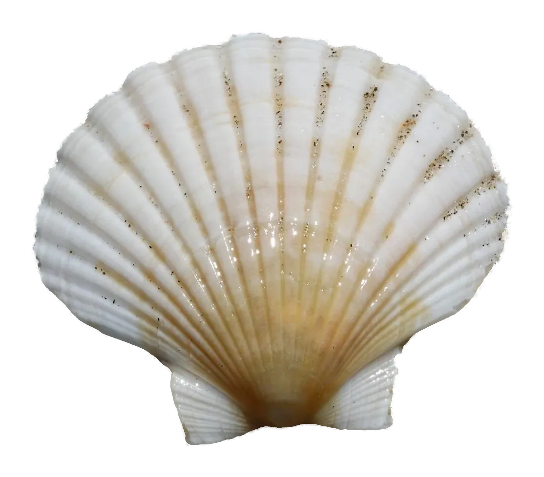
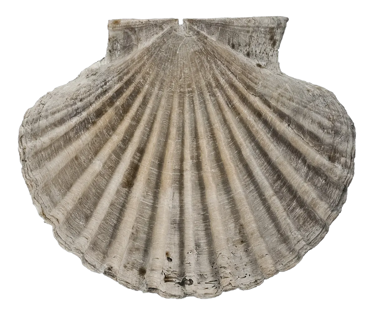
The New Zealand scallop (tipa, Pecten novaezelandiae) is a fan-shaped shellfish found only in New Zealand, with a flat upper shell and a curved lower one. It lies recessed in sand or silt, mostly at 10–50 m. The big northern and Marlborough fisheries are closed, and where scallops are open there is a season.
How to identify scallops
- A large, fan-shaped shell with ribs fanning out from the hinge.
- The upper shell is flat and the lower shell is curved, so a scallop lying on the seabed shows its flat side.
- Usually lies recessed in a hollow in the seabed, often with a film of sand or silt over the top shell.
- Claps its shells to swim away when disturbed, which no other common New Zealand bivalve does.
New Zealand has several fan shells, but the one gathered for food is the large scallop Pecten novaezelandiae. It has a fan-shaped shell with ribs running out from the hinge. The upper shell is flat and the lower shell curved, so when a scallop is lying on the seabed you see the flat side, usually sitting in a shallow hollow and often dusted with sand or silt. Te Aka records the same detail: the top shell is flat and the bottom half curved.
Scallops can swim. When an octopus or starfish comes near, they snap their shells shut, which jets out water and moves them forward. Adults move very little otherwise, but storms can carry them a long way and sometimes throw them up on beaches in large numbers.
The smaller fan shells of the genus Chlamys and the queen scallop (Zygochlamys delicatula) are the main lookalikes. Queen scallops are vividly coloured and come from deep water off the Otago coast, so you are unlikely to meet one while diving for scallops. A subspecies, Pecten novaezelandiae rakiura, is found around Stewart Island.
Often confused with
- Queen scallop
Smaller and vividly coloured, from deep water off Otago. Harvested commercially, not something divers usually meet in scallop beds.
- Fan shells (Chlamys species)
Smaller species of fan shell. The New Zealand scallop is the large one, with one flat and one curved shell.
Size and daily limits
Minimum shell width90–100 mmLimits for each area
| Area | Min. size | Daily limit |
|---|---|---|
| Auckland and Kermadec | 100 mm | 20Details20 per day (also 20 in Auckland Coromandel area), min 100 mm, season 1 September to 31 March. But the whole Northland fishery (SCA 1) is closed since 1 April 2022 and all of the Coromandel fishery (SCA CS) is closed since 17 March 2023 (s11), plus Kaipara Harbour and East Coromandel no take. Not closed by any notice: Bay of Plenty east of Town Point (near Maketū), inner Tauranga Harbour, and the west coast south of Tauroa Point except Kaipara Harbour; there 20 per day, 100 mm, 1 Sep to 31 Mar. Mātaitai bylaws may still apply. Must be landed in the shell (may shuck ones eaten at sea, still counted). A diver on a vessel may take extra limits for up to 2 dive-safety people on board (max 2 extra per vessel). |
| Central | 100 mm | 20Details20 per day, min 100 mm, season 15 July to 14 February. Must be landed in the shell (may shuck ones eaten at sea, still counted). A diver on a vessel may take extra limits for up to 2 dive-safety people on board (max 2 extra per vessel). |
| Challenger | 90 mm | 50Details50 per day, min 90 mm, season 15 July to 14 February. Marlborough Sounds, Tasman Bay, Golden Bay and Port Underwood (Southern scallop fishery, SCA 7) closed since 15 July 2018 until further notice. Outside SCA 7 and Port Underwood (Cloudy/Clifford Bay to Clarence Point, and the West Coast) no closure applies. Must be landed in the shell (may shuck ones eaten at sea, still counted). A diver on a vessel may take extra limits for up to 2 dive-safety people on board (max 2 extra per vessel). |
| Kaikōura | 100 mm | 20DetailsNot part of the 30 "all others" limit. 20 per day, min 100 mm, season 15 Jul to 14 Feb (national). Marfells Beach to Clarence Point (Challenger FMA): 50, min 90 mm; Port Underwood closed. |
| South-East | 100 mm | 20Details20 per day, min 100 mm, season 15 July to 14 February. Must be landed in the shell (may shuck ones eaten at sea, still counted). A diver on a vessel may take extra limits for up to 2 dive-safety people on board (max 2 extra per vessel). |
| Fiordland | None | 0DetailsNo take allowed anywhere in the Fiordland Marine Area (low abundance). |
| Southland | 100 mm | 10Details10 per day, min 100 mm, season 1 October to 15 March. Must be landed in the shell (may shuck ones eaten at sea, still counted). A diver on a vessel may take extra limits for up to 2 dive-safety people on board (max 2 extra per vessel). |
Own daily limit. Size is shell size in mm (measurement method not stated on area pages; see MPI scallop/dredge oyster guidelines PDF).
Closures in force (15)
Auckland and Kermadec3 closures
- No end date
Northland scallop fishery (entire SCA 1 QMA) closed to scallop harvesting from 1 Apr 2022 until further notice (s11). Customary take not restricted.
- No end date
Coromandel scallop fishery (SCA CS): most beds closed April 2022, and all of SCA CS except the Hauturu/Little Barrier Island and Colville Channel areas from 3 Nov 2022 (s11). Those two areas closed by emergency measure (s16) from 16 Dec 2022 to 16 Mar 2023, then all of SCA CS closed from 17 Mar 2023 (Fisheries (SCA CS Closure) Notice 2023, s11). The Nov 2025 plenary gives 1 Apr 2023; the gazetted notice says 17 Mar 2023.
- No end date
Kaipara Harbour and East Coromandel: no taking of scallops (restricted areas list).
Central4 closures
- Until 15 December 2026
Western Taranaki (Tapuae Stream to Taungatara Stream, out 1 nm): all shellfish except rock lobster, seaweed (except beach-cast), sea anemones, stingrays and two conger eel species. From 16 Dec 2024.
- Until 25 July 2027
Tangoiro/Waihirere (Tairāwhiti, near Māwhai Point): all shellfish (incl. rock lobster) and finfish. From 26 Jul 2025.
- Until 25 July 2027
Motuoroi (Anaura Bay, Tairāwhiti): all shellfish (incl. rock lobster) and finfish. From 26 Jul 2025.
- Until 7 August 2027
Te Ohooho o Parapara rāhui: small box approx. 6 km north-east of the Port of Napier; any fish, aquatic life or seaweed. From 8 Aug 2025.
Challenger1 closure
- No end date
Southern scallop fishery (SCA 7: Marlborough Sounds, Tasman Bay, Golden Bay) and Port Underwood closed to scallop fishing since 15 Jul 2018 until further notice.
South-East2 closures
- No end date
Lyttelton Harbour/Whakaraupō and Extension mātaitai: pāua closed at Gollans Bay, north-east Ōtamahua/Quail Island and Livingstone Bay to Godley Head; cockles closed at Walkers Beach (Quail Island) and Rec Bay; no shellfish from whata kaimoana (aquaculture structures); unlisted shellfish prohibited. Rāpaki mātaitai: all shellfish prohibited.
- No end date
Tuhawaiki (south of Timaru) and Te Ahi Tarakihi (north of Timaru) mātaitai reserves: all shellfish other than pāua, kina and kūtai (mussels) prohibited. Limits: pāua 3 (black-foot and yellow-foot), kina 20, kūtai 50 per person per day (MPI 973, in force 24 Jun 2019). Rock lobster treated as shellfish under the Fisheries Act definition (inferred, medium-high confidence). Waitarakao mātaitai (same notice) has no shellfish bylaws.
Fiordland1 closure
- No end date
No take or possession of scallops or flat/dredge oysters anywhere in the Fiordland Marine Area (low abundance).
Southland4 closures
- No end date
Pikomamaku (Womens Island) mātaitai reserve, North Tītī Islands: all fishing prohibited (fish, aquatic life, seaweed).
- No end date
Te Whaka a Te Wera mātaitai reserve (Paterson Inlet, Stewart Island, inside a line from Ackers Point to Bullers Point; Ulva Island marine reserve excluded): pāua closed in the Bravo Islands area (Bravo Island, Gentian Cove coast and 400 m around Tommy, Refuge, Crayfish, Groper and Goat Islands); scallops closed throughout. Elsewhere in the reserve pāua 5 per day; rock lobster pots max 2 per person, 4 per vessel with 2+ people (2006 bylaws).
- No end date
Horomamae mātaitai reserve (waters north and north-east of Horomamae/Owen Island, east Stewart Island): all fish, aquatic life and seaweed closed 1 Jun to 31 Mar (open 1 Apr to 31 May only) (MPI 35, 2012).
- No end date
Kaihuka mātaitai reserve (waters around Kaihuka Island, Breaksea Islands group, east Stewart Island): all fish, aquatic life and seaweed closed 1 Jun to 31 Mar (open 1 Apr to 31 May only) (MPI 37, 2012).
Marine reserves and protected areas: no take57 areas
Poor Knights Islands Marine Reserve (Poor Knights Islands, about 22 km off the east coast of Northland (boats launch from Tutukaka); covers the sea 800 m out from all islands, islets, rocks and stacks). Marine reserve, no take: No fishing of any kind, from a boat or from shore; no taking or disturbing any marine life, including shellfish and seaweeds; no taking any part of the sea floor, including rocks and shells; no feeding fish.
Whangārei Harbour Marine Reserve (Two sites in Whangārei Harbour, Northland: Motukaroro (Passage) Island at Reotahi, and the Waikaraka mudflats and mangroves off Whangārei Heads Road). Marine reserve, no take: Don't take, disturb, kill or damage anything within the reserve.
Cape Rodney-Okakari Point Marine Reserve (Goat Island) (Cape Rodney to Okakari Point near Leigh, north of Warkworth, Auckland; waters 800 m from shore including Te Hāwere-a-Maki/Goat Island (pre-extension description)). Marine reserve, no take: Don't take, disturb, kill or damage anything within the reserve. Extended (Cape Rodney–Okakari Point Extension Marine Reserve) under the Hauraki Gulf / Tīkapa Moana Marine Protection Act 2025 from 25 Oct 2025; the old 800 m boundary no longer marks the edge, check the DOC map.
Tāwharanui Marine Reserve (Northern coast of the Tāwharanui Peninsula (Tāwharanui Regional Park), Rodney, about 90 km north of Auckland). Marine reserve, no take: Don't take, disturb, kill or damage anything within the reserve; no fishing; taking fossils prohibited.
Long Bay-Okura Marine Reserve (Long Bay to the Okura estuary, North Shore, about 20 km north of Auckland CBD). Marine reserve, no take: Don't take, disturb, kill or damage anything within the reserve.
Te Matuku Marine Reserve (Te Matuku Bay, far south-east corner of Waiheke Island, Hauraki Gulf, extending into Tāmaki Strait). Marine reserve, no take: Fishing, collecting, or disturbing marine organisms and resources are prohibited. Don't take, disturb, kill or damage anything within the reserve.
Mōtū Manawa-Pollen Island Marine Reserve (Inner Waitematā Harbour around Pollen and Traherne Islands, between Rosebank Peninsula and Waterview/Pt Chevalier, Auckland). Marine reserve, no take: Do not take or kill fish, crustaceans, shellfish, seaweed, shells, rocks or any other marine life; don't take, disturb, kill or damage anything within the reserve.
Te Whanganui-o-Hei/Cathedral Cove Marine Reserve (Cathedral Cove to Hahei, Mercury Bay, Coromandel). Marine reserve, no take: No fishing of any kind, from a boat or from shore; no taking or disturbing any marine life, including shellfish and seaweeds; no taking any part of the sea floor, including rocks and shells; no feeding fish. No discharge of waste/ballast/sewage. Extended (Te Whanganui-o-Hei / Cathedral Cove Extension Marine Reserve, Areas A and B) under the Hauraki Gulf / Tīkapa Moana Marine Protection Act 2025 from 25 Oct 2025; check the DOC map.
Tūhua (Mayor Island) Marine Reserve (Northern coast of Tūhua/Mayor Island, Bay of Plenty, from high-tide mark to 1 nm offshore between Turanginui Point and Tumutu Point). Marine reserve, no take: Don't take, disturb, kill or damage anything within the reserve. Reserve covers the northern coast only; elsewhere around the island normal rules apply, with set nets and long lines banned within 1 nm.
Te Paepae o Aotea (Volkner Rocks) Marine Reserve (Volkner Rocks, 5 km north-west of Whakaari/White Island and 55 km north of Whakatāne, Bay of Plenty). Marine reserve, no take: Fishing is not permitted. Don't take, disturb, kill or damage anything within the reserve.
Te Tapuwae o Rongokako Marine Reserve (Pouawa coast, about 16 km north of Gisborne, East Coast (access from SH35 at Pouawa)). Marine reserve, no take: Don't take, disturb, kill or damage anything within the reserve.
Te Angiangi Marine Reserve (Central Hawke's Bay coast between Aramoana and Blackhead, about 30 min from Waipukurau/Waipawa). Marine reserve, no take: No fishing, seaweed or shellfish gathering. All plant and animal life, alive or dead, totally protected; reefs and sea floor protected, nothing may be removed. Illegal to discharge firearms or harmful substances, or release non-native species; also an offence to pollute, litter, or erect a structure.
Parininihi Marine Reserve (North Taranaki coast at the Whitecliffs/Parininihi, north of Urenui (road access via Pukearuhe Road), including Pariokariwa reef). Marine reserve, no take: Illegal to take anything, including fish, shellfish, lobster, rocks, shells, driftwood or any other natural feature, plant or animal; don't take, disturb, kill or damage anything. Areas either side were left out of the reserve so customary and recreational fishing continue there.
Tapuae Marine Reserve (Taranaki coast just south-west of New Plymouth, adjoining Ngā Motu/Sugar Loaf Islands Marine Protected Area). Marine reserve, no take: No-take: no fishing of any kind, no shellfish gathering, no removal of rocks, shells, driftwood or plants; don't take, disturb, kill or damage anything. Adjoins the Ngā Motu/Sugar Loaf Islands Marine Protected Area, where some fishing is allowed (not a marine reserve).
Kapiti Marine Reserve (Between Kapiti Island and Paraparaumu/Waikanae beaches, Kapiti Coast, about 30 km from Wellington (two areas: inner/eastern and outer/western of the island)). Marine reserve, no take: Fishing within the marine reserve is not permitted. Don't take, disturb, kill or damage anything within the reserve.
Taputeranga Marine Reserve (Wellington south coast around Island Bay and Owhiro Bay, about 6 km from the city centre). Marine reserve, no take: Fishing and the removal or disturbance of any living or non-living marine resource is prohibited (except permitted monitoring/research).
Westhaven (Te Tai Tapu) Marine Reserve (Tidal sandflats and channels at the southern end of Whanganui Inlet, western Golden Bay; inlet entrance 19 km SW of Farewell Spit). Marine reserve, no take: Fishing and shooting are not permitted in the marine reserve. Don't take, disturb, kill or damage anything within the reserve.
Kahurangi Marine Reserve (Far NW South Island (West Coast region), 16 km of coast from Wekakura Point to Crayfish Point, about 5 km offshore; southern half reachable from the Heaphy Track). Marine reserve, no take: Don't take, disturb, kill or damage anything within the reserve - it's illegal.
Tonga Island Marine Reserve (Abel Tasman National Park coast, Nelson/Tasman, surrounding Tonga Island). Marine reserve, no take: Don't take, disturb, kill or damage anything within the reserve.
Horoirangi Marine Reserve (North of Nelson on the eastern side of Tasman Bay/Te Tai-o-Aorere, Glenduan to near Cable Bay (Ataata Point)). Marine reserve, no take: Don't take, disturb, kill or damage anything within the reserve - it's illegal. Fishing is not permitted within the reserve.
Long Island - Kokomohua Marine Reserve (Entrance to Queen Charlotte Sound, Marlborough Sounds, about 35 km from Picton; boat access only). Marine reserve, no take: Taking, disturbing, killing or damaging anything within the reserve is illegal.
Punakaiki Marine Reserve (West Coast, edge of Paparoa National Park, around Dolomite Point (Pancake Rocks), Perpendicular Point to near Maher Swamp, out to 2 nautical miles). Marine reserve, no take: Don't take, disturb, kill or damage anything within the reserve - it's illegal. Exception: eeling, whitebaiting and recreational fishing at river mouths allowed in two defined areas (not shellfish gathering on the reef).
Waiau Glacier Coast Marine Reserve (South Westland, about 11 km from Kohuamarua Bluff (near Ōkārito) south to Omoeroa Bluff, about 4 km offshore, incl. a short way up the Waiho River). Marine reserve, no take: Don't take, disturb, kill or damage anything within the reserve - it's illegal.
Tauparikākā Marine Reserve (Ship Creek visitor site, about 20 min drive north of Haast, South Westland). Marine reserve, no take: Don't take, disturb, kill or damage anything within the reserve.
Hautai Marine Reserve (Remote South Westland coast, from just south of Longridge Point about 6 km south to the Hacket River mouth, >1 km offshore; halfway between Jackson Bay and Milford Sound, 60 km from any road). Marine reserve, no take: Don't take, disturb, kill or damage anything within the reserve.
Hikurangi Marine Reserve (About 10 km south of Kaikōura near Goose Bay, extending offshore over the Kaikōura Canyon). Marine reserve, no take: No-take area: you may not remove or disturb any marine life, or take any other material, including shells from the beach, water or seabed.
Pōhatu Marine Reserve (Flea Bay, south-east (outer) coast of Banks Peninsula, Canterbury; 4WD-only land access). Marine reserve, no take: It is not permitted to take any animal or natural item from the reserve (fish, shellfish, shells, seaweed, rocks, driftwood).
Akaroa Marine Reserve (Mouth of Akaroa Harbour, Banks Peninsula, Canterbury; boat or kayak access). Marine reserve, no take: You are not permitted to take any animals or natural items from the reserve (fish, shellfish, shells, seaweed, rocks, driftwood).
Waitaki Marine Reserve (North Otago coast south of the Waitaki River; foreshore access limited (much via private land)). Marine reserve, no take: 'No take' area: all fishing (commercial, recreational, customary), taking or killing marine life, removing or disturbing marine life or materials, feeding fish, discarding fish waste. In force 1 Jul 2026 (Te Au Roa o Te Rakihouia network). Only exception is Ngāi Tahu Whānui wānaka (incl. wānaka hī ika with limited take); fish caught outside may be carried through.
Papanui Marine Reserve (Entirely offshore off the Otago Peninsula/Dunedin coast; boat access only). Marine reserve, no take: 'No take' area: all fishing (commercial, recreational, customary), taking or killing marine life, removing or disturbing marine life or materials, feeding fish, discarding fish waste. In force 1 Jul 2026 (Te Au Roa o Te Rakihouia network). Only exception is Ngāi Tahu Whānui wānaka (incl. wānaka hī ika with limited take); fish caught outside may be carried through.
Ōrau Marine Reserve (Dunedin coast, Harakeke Point to St Clair; accessible from Otago Peninsula beaches (Sandfly Bay to St Clair)). Marine reserve, no take: 'No take' area: all fishing (commercial, recreational, customary), taking or killing marine life, removing or disturbing marine life or materials, feeding fish, discarding fish waste. In force 1 Jul 2026 (Te Au Roa o Te Rakihouia network). Only exception is Ngāi Tahu Whānui wānaka (incl. wānaka hī ika with limited take); fish caught outside may be carried through.
Ōkaihae Marine Reserve (Around Ōkaihae/Green Island, offshore island (nature reserve) on the Otago coast south of Dunedin; boat access only). Marine reserve, no take: 'No take' area: all fishing (commercial, recreational, customary), taking or killing marine life, removing or disturbing marine life or materials, feeding fish, discarding fish waste. Landing on Ōkaihae (Green Island) without DOC permission prohibited. In force 1 Jul 2026 (Te Au Roa o Te Rakihouia network). Only exception is Ngāi Tahu Whānui wānaka (incl. wānaka hī ika with limited take); fish caught outside may be carried through.
Hākinikini Marine Reserve (Remote southern Otago coast; limited road access, walk in via Akatore Creek at low tide). Marine reserve, no take: 'No take' area: all fishing (commercial, recreational, customary), taking or killing marine life, removing or disturbing marine life or materials, feeding fish, discarding fish waste. In force 1 Jul 2026 (Te Au Roa o Te Rakihouia network). Only exception is Ngāi Tahu Whānui wānaka (incl. wānaka hī ika with limited take); fish caught outside may be carried through.
Ulva Island-Te Wharawhara Marine Reserve (Outer Paterson Inlet/Whaka ā Te Wera, east coast of Stewart Island/Rakiura, around Ulva Island). Marine reserve, no take: Fishing, or taking or disturbing anything that occurs naturally in the reserve; feeding fish; discharging pollutants or ballast water; introducing living organisms. Surrounded by Te Whaka a Te Wera (Paterson Inlet) mātaitai reserve, which has its own bylaws.
Piopiotahi (Milford Sound) Marine Reserve (Northern side of Milford Sound/Piopiotahi from the head of the sound to Dale Point). Marine reserve, no take: All marine life is totally protected. No fishing, netting, taking, or killing of marine life. No polluting, disturbance or damage. No removal of any natural thing from the marine reserve.
Te Hapua (Sutherland Sound) Marine Reserve (Sutherland Sound, northern Fiordland (shallow-sill entrance)). Marine reserve, no take: All marine life is totally protected. No fishing, netting, taking, or killing of marine life. No polluting, disturbance or damage. No removal of any natural thing from the marine reserve.
Hawea (Clio Rocks) Marine Reserve (Inner Bligh Sound/Hāwea, northern Fiordland). Marine reserve, no take: All marine life is totally protected. No fishing, netting, taking, or killing of marine life. No polluting, disturbance or damage. No removal of any natural thing from the marine reserve.
Kahukura (Gold Arm) Marine Reserve (Gold Arm, Charles Sound/Taiporoporo). Marine reserve, no take: All marine life is totally protected. No fishing, netting, taking, or killing of marine life. No polluting, disturbance or damage. No removal of any natural thing from the marine reserve.
Kutu Parera (Gaer Arm) Marine Reserve (Gaer Arm, Bradshaw Sound (Doubtful Sound complex), incl. Camelot River entrance estuary). Marine reserve, no take: All marine life is totally protected. No fishing, netting, taking, or killing of marine life. No polluting, disturbance or damage. No removal of any natural thing from the marine reserve.
Te Awaatu Channel (The Gut) Marine Reserve (The Gut channel, Doubtful Sound/Patea, near Secretary Island). Marine reserve, no take: All marine life is totally protected. No fishing, netting, taking, or killing of marine life. No polluting, disturbance or damage. No removal of any natural thing from the marine reserve.
Taipari Roa (Elizabeth Island) Marine Reserve (Around Elizabeth Island, inner Doubtful Sound/Patea). Marine reserve, no take: All marine life is totally protected. No fishing, netting, taking, or killing of marine life. No polluting, disturbance or damage. No removal of any natural thing from the marine reserve.
Moana Uta (Wet Jacket Arm) Marine Reserve (Entire length of Wet Jacket Arm, Dusky Sound/Tamatea complex). Marine reserve, no take: All marine life is totally protected. No fishing, netting, taking, or killing of marine life. No polluting, disturbance or damage. No removal of any natural thing from the marine reserve.
Taumoana (Five Fingers Peninsula) Marine Reserve (Beside Five Fingers Peninsula at the entrance to Tamatea/Dusky Sound (wave-exposed coast)). Marine reserve, no take: All marine life is totally protected. No fishing, netting, taking, or killing of marine life. No polluting, disturbance or damage. No removal of any natural thing from the marine reserve.
Te Tapuwae o Hua (Long Sound) Marine Reserve (Long Sound, Preservation Inlet, southern Fiordland). Marine reserve, no take: All marine life is totally protected. No fishing, netting, taking, or killing of marine life. No polluting, disturbance or damage. No removal of any natural thing from the marine reserve.
Aldermen Islands / Te Ruamahua (north) High Protection Area (waters around the northern Aldermen Islands, off Tairua, east Coromandel; boundary per SO plan in the Act, see DOC map). Hauraki Gulf / Tīkapa Moana Marine Protection Act 2025, in force 25 Oct 2025: no recreational or commercial fishing, including rock lobster and all other shellfish. Customary fishing allowed only with written authorisation from a tangata kaitiaki for a customary purpose (e.g. hui, tangi).
Aldermen Islands / Te Ruamahua (south) High Protection Area (waters around the southern Aldermen Islands, off Tairua, east Coromandel; boundary per SO plan in the Act, see DOC map). Hauraki Gulf / Tīkapa Moana Marine Protection Act 2025, in force 25 Oct 2025: no recreational or commercial fishing, including rock lobster and all other shellfish. Customary fishing allowed only with written authorisation from a tangata kaitiaki for a customary purpose (e.g. hui, tangi).
Cape Colville High Protection Area (off Cape Colville, northern tip of the Coromandel Peninsula (inside the Cape Colville SPA); boundary per SO plan in the Act, see DOC map). Hauraki Gulf / Tīkapa Moana Marine Protection Act 2025, in force 25 Oct 2025: no recreational or commercial fishing, including rock lobster and all other shellfish. Customary fishing allowed only with written authorisation from a tangata kaitiaki for a customary purpose (e.g. hui, tangi).
Kawau Bay High Protection Area (Kawau Bay, north of Auckland (inside the Kawau Bay SPA); boundary per SO plan in the Act, see DOC map). Hauraki Gulf / Tīkapa Moana Marine Protection Act 2025, in force 25 Oct 2025: no recreational or commercial fishing, including rock lobster and all other shellfish. Customary fishing allowed only with written authorisation from a tangata kaitiaki for a customary purpose (e.g. hui, tangi). Limited commercial ring-netting (kahawai, grey mullet, trevally, 1 Mar to 31 Aug, authorised existing operators only) is the only fishing exception; it does not apply to recreational fishers.
Mokohīnau Islands High Protection Area (around the Mokohīnau Islands, outer Hauraki Gulf; boundary per SO plan in the Act, see DOC map). Hauraki Gulf / Tīkapa Moana Marine Protection Act 2025, in force 25 Oct 2025: no recreational or commercial fishing, including rock lobster and all other shellfish. Customary fishing allowed only with written authorisation from a tangata kaitiaki for a customary purpose (e.g. hui, tangi).
Motukawao Islands High Protection Area (around the Motukawao Islands, western Coromandel coast; boundary per SO plan in the Act, see DOC map). Hauraki Gulf / Tīkapa Moana Marine Protection Act 2025, in force 25 Oct 2025: no recreational or commercial fishing, including rock lobster and all other shellfish. Customary fishing allowed only with written authorisation from a tangata kaitiaki for a customary purpose (e.g. hui, tangi).
Pakatoa and Tarahiki / Shag Island High Protection Area (around Pakatoa and Tarahiki/Shag Islands, east of Waiheke Island; boundary per SO plan in the Act, see DOC map). Hauraki Gulf / Tīkapa Moana Marine Protection Act 2025, in force 25 Oct 2025: no recreational or commercial fishing, including rock lobster and all other shellfish. Customary fishing allowed only with written authorisation from a tangata kaitiaki for a customary purpose (e.g. hui, tangi).
Rangitoto and Motutapu High Protection Area (around Rangitoto and Motutapu Islands, inner Hauraki Gulf; boundary per SO plan in the Act, see DOC map). Hauraki Gulf / Tīkapa Moana Marine Protection Act 2025, in force 25 Oct 2025: no recreational or commercial fishing, including rock lobster and all other shellfish. Customary fishing allowed only with written authorisation from a tangata kaitiaki for a customary purpose (e.g. hui, tangi). Limited commercial ring-netting (kahawai, grey mullet, trevally, 1 Mar to 31 Aug, authorised existing operators only) is the only fishing exception; it does not apply to recreational fishers.
Slipper Island / Whakahau High Protection Area (around Slipper Island/Whakahau, off Tairua-Pāuanui, east Coromandel; boundary per SO plan in the Act, see DOC map). Hauraki Gulf / Tīkapa Moana Marine Protection Act 2025, in force 25 Oct 2025: no recreational or commercial fishing, including rock lobster and all other shellfish. Customary fishing allowed only with written authorisation from a tangata kaitiaki for a customary purpose (e.g. hui, tangi).
Te Hauturu-o-Toi / Little Barrier Island High Protection Area (around Te Hauturu-o-Toi/Little Barrier Island, outer Hauraki Gulf; boundary per SO plan in the Act, see DOC map). Hauraki Gulf / Tīkapa Moana Marine Protection Act 2025, in force 25 Oct 2025: no recreational or commercial fishing, including rock lobster and all other shellfish. Customary fishing allowed only with written authorisation from a tangata kaitiaki for a customary purpose (e.g. hui, tangi).
The Noises High Protection Area (around The Noises islands, north-east of Rangitoto/Motutapu; boundary per SO plan in the Act, see DOC map). Hauraki Gulf / Tīkapa Moana Marine Protection Act 2025, in force 25 Oct 2025: no recreational or commercial fishing, including rock lobster and all other shellfish. Customary fishing allowed only with written authorisation from a tangata kaitiaki for a customary purpose (e.g. hui, tangi).
Tiritiri Matangi High Protection Area (around Tiritiri Matangi Island, off Whangaparāoa Peninsula (inside the Tiritiri Matangi SPA); boundary per SO plan in the Act, see DOC map). Hauraki Gulf / Tīkapa Moana Marine Protection Act 2025, in force 25 Oct 2025: no recreational or commercial fishing, including rock lobster and all other shellfish. Customary fishing allowed only with written authorisation from a tangata kaitiaki for a customary purpose (e.g. hui, tangi).
Kermadec Islands Marine Reserve (Rangitāhua): all waters around the islands and rocks out to 12 nautical miles. Marine reserve, no take of any marine life. Visits need a DOC permit.
Before you gather
- Check the MPI shellfish biotoxin alerts for the beach you're going to. Toxins can't be cooked out.
- Check for rāhui, mātaitai and other customary management areas, which can have their own limits or closures.
Checked 23 October 2026 · Source: MPI. Rules and closures change, so check the NZ Fishing Rules app before you gather.
Where it lives in New Zealand
Scallops are found around New Zealand on shell, gravel, sand and sometimes silt, from the low-tide mark down to about 60 m (and deeper at the Chatham Islands). They are most common at 10 to 50 m. Beds tend to form in semi-enclosed bays and harbours, where circulating currents are thought to keep the larvae close to home. Beds are patchy: some last for years, others appear and vanish.
In a few harbours you can reach scallops by hand in the shallow subtidal, or even on the lowest spring tides, but most are gathered by diving or with a small dredge from a boat.
Many of the best-known scallop grounds are closed. The whole Northland fishery was closed in 2022 after a 2021 survey found few scallops of legal size. Most of the Coromandel and Hauraki Gulf fishery closed the same year, and the last two open areas, near Te Hauturu-o-Toi (Little Barrier Island) and in the Colville Channel, were closed by emergency order in December 2022 after camera surveys showed serious declines. Kaipara Harbour was closed after a 2017 survey found a severe decline. In the top of the South Island, the Marlborough Sounds, Tasman Bay and Golden Bay fishery has been closed for years, and scallops cannot be taken anywhere in the Fiordland Marine Area.
Some areas are still open, each with its own season, limit and minimum size. They include parts of the Bay of Plenty and the west coast of the North Island, coastal areas in the Central and South-East fishing areas, Stewart Island and the coast between Cloudy Bay and Clarence Point. Mātaitai bylaws can still apply there. See the limits by area and the closures below.
In August 2026, Fisheries New Zealand consulted on reopening Whangārei Harbour to a limited recreational scallop season, with a ban on dredging, while the rest of the Northland fishery stays closed. Recreational fishing groups argued for keeping it closed. As of 23 October 2026 no decision had been announced.
How to gather it
Most recreational scallops are taken by divers, on snorkel or scuba. Unlike pāua, scallops can be gathered with scuba. Look for the flat upper shell in a shallow hollow on the seabed, often under a film of sand or silt, and pick them up by hand. Diving lets you check each scallop before you take it and leave the small ones on the bed. Carry a measuring gauge, and see MPI's scallop and oyster guide for how to measure.
Small dredges towed from a boat are also used in some areas. Dredging is less selective, and it is hard on the beds. In a Fisheries New Zealand study of commercial dredges in the Coromandel, total incidental mortality was 20 to 30%, and possibly as high as 50% for undersized scallops thrown back. Toothed box dredges did more damage than ring-bag dredges. Dredging also makes the seabed more uniform, which raises the death rate of young scallops. The Whangārei Harbour proposal included a dredging ban. Check the rules for your area before using a dredge.
Scallops must be landed in the shell. You may shuck scallops you eat at sea, but they still count towards your daily limit. Divers on a boat can take extra limits for people on board acting as dive safety; the notes in the table give the details.
Customary harvest continues in the closed northern fisheries under authorisations issued by tangata kaitiaki. Respect rāhui and mātaitai: a rāhui is a customary ban set by tangata whenua, and mātaitai reserves can have their own bylaws. MPI publishes the rules and maps for each customary management area.
Eating
New Zealanders traditionally eat the whole scallop meat, both the white adductor muscle and the orange roe, while many overseas cooks keep only the white muscle. Scallops need very little cooking: sear them in a hot pan for a minute or so a side, or add them at the very end of a dish. Overcooked scallops turn rubbery.
Scallops are filter feeders, like other bivalves, and are included in MPI's shellfish biotoxin alerts. Check the alerts for that coast before you go, and remember that cooking does not destroy biotoxins. If you feel unwell after eating shellfish, with tingling around the mouth or in the fingers and toes, dizziness, or difficulty breathing or swallowing, call Healthline on 0800 611 116 or get medical help straight away.
Recipes
- Scallop and watercress salad (Seafood New Zealand)
- Scallop balls (Seafood New Zealand)
Good to know
Scallop numbers swing a lot from year to year, even without fishing. A single scallop can release millions of eggs, and survival of larvae and young scallops varies widely, so a fishery can depend on one or two good year classes. Fishing makes this worse by removing the large, older scallops, which produce far more eggs than small ones. Habitat matters too: in laboratory studies, suspended sediment disrupted feeding, slowed growth and killed scallops, and young scallops survive better on seabed with plenty of growth on it than on bare, uniform ground.
The fall in recreational scallop gathering is the steepest of any shellfish. MPI's national panel survey estimated that recreational fishers took about 1.67 million scallops in 2011–12 and 562,000 in 2017–18, but only about 20,000 in 2022–23, after the northern closures. The survey's authors note that the closures explain much of the drop, and that the latest figure is uncertain because few households reported scallops.
Scallops are functional hermaphrodites: each one produces both eggs and sperm. They mature at about 70 mm, spawn several times a year with most spawning in spring and early summer, and release their eggs and sperm into the water. A one-year-old scallop carries about 500,000 eggs, and a four or five-year-old more than 40 million. Larvae drift for about three weeks, then settle on seaweed, hydroids and other fine growth, holding on with byssus threads until they drop to the seabed. Growth varies a lot: in parts of the Hauraki Gulf scallops reach legal size in 18 months or less, but elsewhere it takes three years or more. They probably live no more than six or seven years. Starfish, octopus, hermit crabs, snapper, tarakihi and blue cod all eat them.
Questions
Is scallop season open?
It depends on where you are. The Northland, Coromandel and Hauraki Gulf, Kaipara, Marlborough Sounds, Tasman Bay and Golden Bay fisheries are closed, and so is Fiordland. Other areas open for a season each year. See the limits, seasons and closures by area below.
Why are scallops closed in Northland and the Coromandel?
Surveys in 2021 and 2022 found low numbers of legal-size scallops and serious declines in the remaining beds. The Minister closed the fisheries to protect what was left. Fishing, sediment and habitat loss all affect scallop beds.
Can I dive for scallops with scuba?
Yes. Unlike pāua, scallops can be gathered with scuba where the fishery is open.
How many scallops can I take?
Limits and minimum sizes differ by area. See the table below, which shows the current rules for each area and when we last checked them against MPI.
Do you eat the orange part of a scallop?
Yes. The orange part is the roe, and New Zealanders traditionally eat it along with the white muscle.