Mussels
Kuku (green-lipped mussel, Perna canaliculus), Kūtai (mussel of several species)
Perna canaliculus, Mytilus planulatus formerly Mytilus galloprovincialisAlso known as Green-lipped mussel, Greenshell mussel, Blue mussel
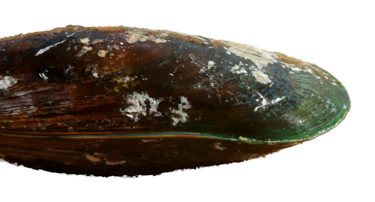
New Zealand's two mussels gathered for food are the big green-lipped mussel (kuku), farmed as the Greenshell mussel, and the smaller blue mussel. Both grow in clumps on rocks and wharf piles and are gathered by hand at low tide.
How to identify mussels
- Green-lipped mussel: a large shell with a green band around the edge (the green lip). Farmed ones are harvested at about 8–10 cm; wild ones vary widely, and old ones can grow to 20 cm or more, and over 240 mm at most.
- Blue mussel: smaller than a green-lipped mussel, with a blue-black shell and no green edge.
- Both grow in clumps, held on by the tough threads of the beard.
New Zealand has 22 species of true mussel, but two are gathered for food. The green-lipped mussel (Perna canaliculus) is the big one, and the one farmed commercially as the Greenshell mussel. It is easy to recognise by the green band around the edge of the shell. The blue mussel is smaller, with a blue-black shell. The World Register of Marine Species lists the native Australasian blue mussel as Mytilus planulatus. New Zealand references, including Te Ara and Te Papa, often call it Mytilus galloprovincialis, and the fishing regulations still use the old name Mytilus edulis aoteanus. Both mussels grow in clumps on rocks and wharf piles, held on by the tough threads of the "beard".
Often confused with
- Blue mussel
Smaller than a green-lipped mussel, with a blue-black shell and no green band around the edge.
- Horse mussel
New Zealand's largest living shellfish, usually 30–35 cm long. It lives in soft sediment rather than on rocks, and is closed to gathering in some areas such as Ōhiwa Harbour.
Size and daily limits
Daily limitVaries by areaLimits for each area
| Area | Min. size | Daily limit |
|---|---|---|
| Auckland and Kermadec | None | Varies by sub-areaDetailsMussels (green-lipped, blue and horse mussels together, reg 2): 50 per day combined generally. Auckland Coromandel area: 50 combined with up to 25 green-lipped until 31 Oct 2026; from 1 Nov 2026 green-lipped 10 per day, within the national mussel limit of 50 combined (RMC Notice No. 2 2026 cl 12.1 and 5.1). Blue and horse mussels are not under the area's "any other shellfish" 10, which covers only shellfish without a limit in Part 1 or 2 of the notice; "mussel" has one in Part 1. No take in the Auckland Coromandel intertidal zone (high-water mark to 2 m depth) from 1 Nov 2026. No minimum size. Closures: Waiheke Island (1 nm) and Te Mātā/Waipatukahu (to 6 Aug 2028), Te Puna mātaitai (green-lipped, blue and black mussels), Rehuotane Ki Tai (to 25 Jun 2028), Marsden/Mair Banks (to 28 Jun 2028), Ōmaha Bay/Kawau Bay/Whangaparāoa rock pools (to 11 Mar 2028), Ōhiwa Harbour (renewed to 12 Nov 2028). Mt Maunganui / part Tauranga Harbour mātaitai: mussels 25 per day (2009 bylaws). |
| Central | None | 50DetailsTable says "Mussels". No minimum size. Ōhiwa Harbour (Te rāhui kuku ki tua o Kanawa) closed to mussels, renewed to 12 Nov 2028. |
| Challenger | None | 50DetailsTable says "Mussels". No minimum size. Makaawhio mātaitai: 20, except no take at Ōkārito. |
| Kaikōura | None | 50DetailsTable says "Mussels". No minimum size. Oaro-Haumuri Taiāpure closed to shellfish other than scampi, rock lobster, octopus, kina (and pāua in season). |
| South-East | None | 50DetailsTable says "Mussels". No minimum size generally. Lyttelton Harbour/Whakaraupō and Extension mātaitai: 30, green-lipped min 70 mm (greatest overall shell length); Rāpaki mātaitai no take. |
| Fiordland | None | 10DetailsTable says "Mussels". No minimum size. Same inside and outside the Fiords. |
| Southland | None | 25DetailsTable says "Mussels". 25 per day excluding Stewart Island, where it is 50. No minimum size. |
Own daily limit. "Mussel" in the Amateur Fishing Regulations (reg 2) means green-lipped, blue and horse mussels, so blue mussels count toward the mussel limit, not "all other shellfish".
Closures in force (21)
Auckland and Kermadec7 closures
- Until 6 August 2028
Te Mātā and Waipatukahu (Ōtaki Creek to Diehard/Onepoto Stream, out 1 nm): cockles, mussels, oysters, pipi. From 7 Aug 2026.
- Until 6 August 2028
Waiheke Island, within 1 nm (excludes Te Matuku Marine Reserve): mussels, pāua and packhorse rock lobster. Scallops and spiny rock lobster already closed there. From 7 Aug 2026.
- Until 28 June 2028
Marsden Bank and Mair Bank, Whangārei Harbour entrance: all shellfish, including kina, sea cucumbers and packhorse rock lobster (the notice defines shellfish as all echinoderms, molluscs and crustaceans). Pipi, scallop and spiny rock lobster are closed by other measures. From 29 Jun 2026.
- Until 11 March 2028
Ōmaha Bay, Kawau Bay and Whangaparāoa Peninsula: all invertebrates and seaweed in rock pools and out to 200 m offshore, from 12 Mar 2026. Kina excluded (normal limits apply); spiny rock lobster and scallops already closed.
- Until 25 June 2028
Rehuotane Ki Tai (Tutukaka Harbour, Ngunguru Bay, Ngunguru and Horahora Rivers): no taking cockle, crab, garfish, mussel, octopus, pāua, pipi, packhorse rock lobster, rock oyster, sea cucumber, sea horse, sea snail, starfish, tuatua; nets prohibited in harbour/rivers. From 26 Jun 2026.
- No end date
Standing shellfish restrictions (restricted areas list, no end date shown): Cheltenham Beach, Eastern Beach and Karekare Beach no shellfish gathering; Cockle Bay no taking of shellfish; Whangateau Harbour no cockles or pipi; Ngunguru Estuary no pipi and/or cockles; Te Puna mātaitai no green-lipped, blue or black mussels; Maunganui Bay (Deep Water Cove) no taking of any species except kina.
- No end date
Auckland Coromandel intertidal closure: from 1 Nov 2026, from the high-water mark out to 2 m depth on the east coast from Cape Rodney to Houmanga Point, the west coast from the Ōkiritoto Stream to the Port Waikato sandspit, and all of Waiheke Island. Closed to all invertebrates except cockle, crab, kina, octopus, oyster, pāua, pipi, rock lobster, scallop, sea cucumber, shrimp/prawn, squid and tuatua. Mussels are not exempt.
Auckland and Kermadec, Central1 closure
- Until 12 November 2028
Ōhiwa Harbour (Te rāhui kuku ki tua o Kanawa): green-lipped, blue and horse mussels closed. Renewed from 13 Nov 2026 for 2 years. Listed on both the Auckland/Kermadec and Central pages.
Central7 closures
- Until 15 December 2026
Western Taranaki (Tapuae Stream to Taungatara Stream, out 1 nm): all shellfish except rock lobster, seaweed (except beach-cast), sea anemones, stingrays and two conger eel species. From 16 Dec 2024.
- Until 25 July 2027
Tangoiro/Waihirere (Tairāwhiti, near Māwhai Point): all shellfish (incl. rock lobster) and finfish. From 26 Jul 2025.
- Until 25 July 2027
Motuoroi (Anaura Bay, Tairāwhiti): all shellfish (incl. rock lobster) and finfish. From 26 Jul 2025.
- Until 7 August 2027
Te Ohooho o Parapara rāhui: small box approx. 6 km north-east of the Port of Napier; any fish, aquatic life or seaweed. From 8 Aug 2025.
- No end date
Toka Tāmure mātaitai reserve (Māhia Peninsula) bylaws (MPI 599, 2016): no taking of pāua, mussels, pipi, tuatua, cockles, surf clams, deepwater clams, packhorse rock lobster, sea cucumber, karengo or beach-cast seaweed. Kina closed 1 Mar to 31 Jul; 25 per day 1 Aug to end of Feb. Spiny rock lobster 3 per day; no loops for rock lobster. No UBA for taking fish, shellfish or seaweed.
- No end date
Horokaka mātaitai reserve (Māhia Peninsula) bylaws (MPI 919, 2018): no taking of pāua, mussels, pipi, tuatua, cockles, surf clams, deepwater clams, packhorse rock lobster, sea cucumber, karengo or beach-cast seaweed. Spiny rock lobster closed 1 May to 30 Sep, 3 per day 1 Oct to 30 Apr; no loops. Kina closed 1 Apr to 30 Sep, 25 per day 1 Oct to 31 Mar. No UBA for taking fish, shellfish or seaweed.
- No end date
Te Hoe mātaitai reserve (Māhia Peninsula), Waikokopu to Opoutama section only: no taking of kina, rock lobster (kōura), mussels (kuku) or pāua (MPI 1413, in force 17 Dec 2021).
Kaikōura1 closure
- No end date
Oaro-Haumuri Taiāpure: closed to seaweed and shellfish except scampi, rock lobster, octopus and kina (pāua open in season at 2 per day).
Challenger1 closure
- No end date
Makaawhio (West Coast) mātaitai reserves bylaws: pāua no take at Okāhu, Okuru, Popotai Taumaka, Mahitahi and Ōkārito; rock lobster no take at Ōkārito, Manakaiaua, Mahitahi, Tauparikaka and Okuru, max tail width 70 mm and vessel limit 18 elsewhere; mussels no take at Ōkārito; reduced limits (20) or no take for mussels, cockles, pipi and tuatua; any shellfish not listed prohibited.
South-East1 closure
- No end date
Lyttelton Harbour/Whakaraupō and Extension mātaitai: pāua closed at Gollans Bay, north-east Ōtamahua/Quail Island and Livingstone Bay to Godley Head; cockles closed at Walkers Beach (Quail Island) and Rec Bay; no shellfish from whata kaimoana (aquaculture structures); unlisted shellfish prohibited. Rāpaki mātaitai: all shellfish prohibited.
Southland3 closures
- No end date
Pikomamaku (Womens Island) mātaitai reserve, North Tītī Islands: all fishing prohibited (fish, aquatic life, seaweed).
- No end date
Horomamae mātaitai reserve (waters north and north-east of Horomamae/Owen Island, east Stewart Island): all fish, aquatic life and seaweed closed 1 Jun to 31 Mar (open 1 Apr to 31 May only) (MPI 35, 2012).
- No end date
Kaihuka mātaitai reserve (waters around Kaihuka Island, Breaksea Islands group, east Stewart Island): all fish, aquatic life and seaweed closed 1 Jun to 31 Mar (open 1 Apr to 31 May only) (MPI 37, 2012).
Marine reserves and protected areas: no take57 areas
Poor Knights Islands Marine Reserve (Poor Knights Islands, about 22 km off the east coast of Northland (boats launch from Tutukaka); covers the sea 800 m out from all islands, islets, rocks and stacks). Marine reserve, no take: No fishing of any kind, from a boat or from shore; no taking or disturbing any marine life, including shellfish and seaweeds; no taking any part of the sea floor, including rocks and shells; no feeding fish.
Whangārei Harbour Marine Reserve (Two sites in Whangārei Harbour, Northland: Motukaroro (Passage) Island at Reotahi, and the Waikaraka mudflats and mangroves off Whangārei Heads Road). Marine reserve, no take: Don't take, disturb, kill or damage anything within the reserve.
Cape Rodney-Okakari Point Marine Reserve (Goat Island) (Cape Rodney to Okakari Point near Leigh, north of Warkworth, Auckland; waters 800 m from shore including Te Hāwere-a-Maki/Goat Island (pre-extension description)). Marine reserve, no take: Don't take, disturb, kill or damage anything within the reserve. Extended (Cape Rodney–Okakari Point Extension Marine Reserve) under the Hauraki Gulf / Tīkapa Moana Marine Protection Act 2025 from 25 Oct 2025; the old 800 m boundary no longer marks the edge, check the DOC map.
Tāwharanui Marine Reserve (Northern coast of the Tāwharanui Peninsula (Tāwharanui Regional Park), Rodney, about 90 km north of Auckland). Marine reserve, no take: Don't take, disturb, kill or damage anything within the reserve; no fishing; taking fossils prohibited.
Long Bay-Okura Marine Reserve (Long Bay to the Okura estuary, North Shore, about 20 km north of Auckland CBD). Marine reserve, no take: Don't take, disturb, kill or damage anything within the reserve.
Te Matuku Marine Reserve (Te Matuku Bay, far south-east corner of Waiheke Island, Hauraki Gulf, extending into Tāmaki Strait). Marine reserve, no take: Fishing, collecting, or disturbing marine organisms and resources are prohibited. Don't take, disturb, kill or damage anything within the reserve.
Mōtū Manawa-Pollen Island Marine Reserve (Inner Waitematā Harbour around Pollen and Traherne Islands, between Rosebank Peninsula and Waterview/Pt Chevalier, Auckland). Marine reserve, no take: Do not take or kill fish, crustaceans, shellfish, seaweed, shells, rocks or any other marine life; don't take, disturb, kill or damage anything within the reserve.
Te Whanganui-o-Hei/Cathedral Cove Marine Reserve (Cathedral Cove to Hahei, Mercury Bay, Coromandel). Marine reserve, no take: No fishing of any kind, from a boat or from shore; no taking or disturbing any marine life, including shellfish and seaweeds; no taking any part of the sea floor, including rocks and shells; no feeding fish. No discharge of waste/ballast/sewage. Extended (Te Whanganui-o-Hei / Cathedral Cove Extension Marine Reserve, Areas A and B) under the Hauraki Gulf / Tīkapa Moana Marine Protection Act 2025 from 25 Oct 2025; check the DOC map.
Tūhua (Mayor Island) Marine Reserve (Northern coast of Tūhua/Mayor Island, Bay of Plenty, from high-tide mark to 1 nm offshore between Turanginui Point and Tumutu Point). Marine reserve, no take: Don't take, disturb, kill or damage anything within the reserve. Reserve covers the northern coast only; elsewhere around the island normal rules apply, with set nets and long lines banned within 1 nm.
Te Paepae o Aotea (Volkner Rocks) Marine Reserve (Volkner Rocks, 5 km north-west of Whakaari/White Island and 55 km north of Whakatāne, Bay of Plenty). Marine reserve, no take: Fishing is not permitted. Don't take, disturb, kill or damage anything within the reserve.
Te Tapuwae o Rongokako Marine Reserve (Pouawa coast, about 16 km north of Gisborne, East Coast (access from SH35 at Pouawa)). Marine reserve, no take: Don't take, disturb, kill or damage anything within the reserve.
Te Angiangi Marine Reserve (Central Hawke's Bay coast between Aramoana and Blackhead, about 30 min from Waipukurau/Waipawa). Marine reserve, no take: No fishing, seaweed or shellfish gathering. All plant and animal life, alive or dead, totally protected; reefs and sea floor protected, nothing may be removed. Illegal to discharge firearms or harmful substances, or release non-native species; also an offence to pollute, litter, or erect a structure.
Parininihi Marine Reserve (North Taranaki coast at the Whitecliffs/Parininihi, north of Urenui (road access via Pukearuhe Road), including Pariokariwa reef). Marine reserve, no take: Illegal to take anything, including fish, shellfish, lobster, rocks, shells, driftwood or any other natural feature, plant or animal; don't take, disturb, kill or damage anything. Areas either side were left out of the reserve so customary and recreational fishing continue there.
Tapuae Marine Reserve (Taranaki coast just south-west of New Plymouth, adjoining Ngā Motu/Sugar Loaf Islands Marine Protected Area). Marine reserve, no take: No-take: no fishing of any kind, no shellfish gathering, no removal of rocks, shells, driftwood or plants; don't take, disturb, kill or damage anything. Adjoins the Ngā Motu/Sugar Loaf Islands Marine Protected Area, where some fishing is allowed (not a marine reserve).
Kapiti Marine Reserve (Between Kapiti Island and Paraparaumu/Waikanae beaches, Kapiti Coast, about 30 km from Wellington (two areas: inner/eastern and outer/western of the island)). Marine reserve, no take: Fishing within the marine reserve is not permitted. Don't take, disturb, kill or damage anything within the reserve.
Taputeranga Marine Reserve (Wellington south coast around Island Bay and Owhiro Bay, about 6 km from the city centre). Marine reserve, no take: Fishing and the removal or disturbance of any living or non-living marine resource is prohibited (except permitted monitoring/research).
Westhaven (Te Tai Tapu) Marine Reserve (Tidal sandflats and channels at the southern end of Whanganui Inlet, western Golden Bay; inlet entrance 19 km SW of Farewell Spit). Marine reserve, no take: Fishing and shooting are not permitted in the marine reserve. Don't take, disturb, kill or damage anything within the reserve.
Kahurangi Marine Reserve (Far NW South Island (West Coast region), 16 km of coast from Wekakura Point to Crayfish Point, about 5 km offshore; southern half reachable from the Heaphy Track). Marine reserve, no take: Don't take, disturb, kill or damage anything within the reserve - it's illegal.
Tonga Island Marine Reserve (Abel Tasman National Park coast, Nelson/Tasman, surrounding Tonga Island). Marine reserve, no take: Don't take, disturb, kill or damage anything within the reserve.
Horoirangi Marine Reserve (North of Nelson on the eastern side of Tasman Bay/Te Tai-o-Aorere, Glenduan to near Cable Bay (Ataata Point)). Marine reserve, no take: Don't take, disturb, kill or damage anything within the reserve - it's illegal. Fishing is not permitted within the reserve.
Long Island - Kokomohua Marine Reserve (Entrance to Queen Charlotte Sound, Marlborough Sounds, about 35 km from Picton; boat access only). Marine reserve, no take: Taking, disturbing, killing or damaging anything within the reserve is illegal.
Punakaiki Marine Reserve (West Coast, edge of Paparoa National Park, around Dolomite Point (Pancake Rocks), Perpendicular Point to near Maher Swamp, out to 2 nautical miles). Marine reserve, no take: Don't take, disturb, kill or damage anything within the reserve - it's illegal. Exception: eeling, whitebaiting and recreational fishing at river mouths allowed in two defined areas (not shellfish gathering on the reef).
Waiau Glacier Coast Marine Reserve (South Westland, about 11 km from Kohuamarua Bluff (near Ōkārito) south to Omoeroa Bluff, about 4 km offshore, incl. a short way up the Waiho River). Marine reserve, no take: Don't take, disturb, kill or damage anything within the reserve - it's illegal.
Tauparikākā Marine Reserve (Ship Creek visitor site, about 20 min drive north of Haast, South Westland). Marine reserve, no take: Don't take, disturb, kill or damage anything within the reserve.
Hautai Marine Reserve (Remote South Westland coast, from just south of Longridge Point about 6 km south to the Hacket River mouth, >1 km offshore; halfway between Jackson Bay and Milford Sound, 60 km from any road). Marine reserve, no take: Don't take, disturb, kill or damage anything within the reserve.
Hikurangi Marine Reserve (About 10 km south of Kaikōura near Goose Bay, extending offshore over the Kaikōura Canyon). Marine reserve, no take: No-take area: you may not remove or disturb any marine life, or take any other material, including shells from the beach, water or seabed.
Pōhatu Marine Reserve (Flea Bay, south-east (outer) coast of Banks Peninsula, Canterbury; 4WD-only land access). Marine reserve, no take: It is not permitted to take any animal or natural item from the reserve (fish, shellfish, shells, seaweed, rocks, driftwood).
Akaroa Marine Reserve (Mouth of Akaroa Harbour, Banks Peninsula, Canterbury; boat or kayak access). Marine reserve, no take: You are not permitted to take any animals or natural items from the reserve (fish, shellfish, shells, seaweed, rocks, driftwood).
Waitaki Marine Reserve (North Otago coast south of the Waitaki River; foreshore access limited (much via private land)). Marine reserve, no take: 'No take' area: all fishing (commercial, recreational, customary), taking or killing marine life, removing or disturbing marine life or materials, feeding fish, discarding fish waste. In force 1 Jul 2026 (Te Au Roa o Te Rakihouia network). Only exception is Ngāi Tahu Whānui wānaka (incl. wānaka hī ika with limited take); fish caught outside may be carried through.
Papanui Marine Reserve (Entirely offshore off the Otago Peninsula/Dunedin coast; boat access only). Marine reserve, no take: 'No take' area: all fishing (commercial, recreational, customary), taking or killing marine life, removing or disturbing marine life or materials, feeding fish, discarding fish waste. In force 1 Jul 2026 (Te Au Roa o Te Rakihouia network). Only exception is Ngāi Tahu Whānui wānaka (incl. wānaka hī ika with limited take); fish caught outside may be carried through.
Ōrau Marine Reserve (Dunedin coast, Harakeke Point to St Clair; accessible from Otago Peninsula beaches (Sandfly Bay to St Clair)). Marine reserve, no take: 'No take' area: all fishing (commercial, recreational, customary), taking or killing marine life, removing or disturbing marine life or materials, feeding fish, discarding fish waste. In force 1 Jul 2026 (Te Au Roa o Te Rakihouia network). Only exception is Ngāi Tahu Whānui wānaka (incl. wānaka hī ika with limited take); fish caught outside may be carried through.
Ōkaihae Marine Reserve (Around Ōkaihae/Green Island, offshore island (nature reserve) on the Otago coast south of Dunedin; boat access only). Marine reserve, no take: 'No take' area: all fishing (commercial, recreational, customary), taking or killing marine life, removing or disturbing marine life or materials, feeding fish, discarding fish waste. Landing on Ōkaihae (Green Island) without DOC permission prohibited. In force 1 Jul 2026 (Te Au Roa o Te Rakihouia network). Only exception is Ngāi Tahu Whānui wānaka (incl. wānaka hī ika with limited take); fish caught outside may be carried through.
Hākinikini Marine Reserve (Remote southern Otago coast; limited road access, walk in via Akatore Creek at low tide). Marine reserve, no take: 'No take' area: all fishing (commercial, recreational, customary), taking or killing marine life, removing or disturbing marine life or materials, feeding fish, discarding fish waste. In force 1 Jul 2026 (Te Au Roa o Te Rakihouia network). Only exception is Ngāi Tahu Whānui wānaka (incl. wānaka hī ika with limited take); fish caught outside may be carried through.
Ulva Island-Te Wharawhara Marine Reserve (Outer Paterson Inlet/Whaka ā Te Wera, east coast of Stewart Island/Rakiura, around Ulva Island). Marine reserve, no take: Fishing, or taking or disturbing anything that occurs naturally in the reserve; feeding fish; discharging pollutants or ballast water; introducing living organisms. Surrounded by Te Whaka a Te Wera (Paterson Inlet) mātaitai reserve, which has its own bylaws.
Piopiotahi (Milford Sound) Marine Reserve (Northern side of Milford Sound/Piopiotahi from the head of the sound to Dale Point). Marine reserve, no take: All marine life is totally protected. No fishing, netting, taking, or killing of marine life. No polluting, disturbance or damage. No removal of any natural thing from the marine reserve.
Te Hapua (Sutherland Sound) Marine Reserve (Sutherland Sound, northern Fiordland (shallow-sill entrance)). Marine reserve, no take: All marine life is totally protected. No fishing, netting, taking, or killing of marine life. No polluting, disturbance or damage. No removal of any natural thing from the marine reserve.
Hawea (Clio Rocks) Marine Reserve (Inner Bligh Sound/Hāwea, northern Fiordland). Marine reserve, no take: All marine life is totally protected. No fishing, netting, taking, or killing of marine life. No polluting, disturbance or damage. No removal of any natural thing from the marine reserve.
Kahukura (Gold Arm) Marine Reserve (Gold Arm, Charles Sound/Taiporoporo). Marine reserve, no take: All marine life is totally protected. No fishing, netting, taking, or killing of marine life. No polluting, disturbance or damage. No removal of any natural thing from the marine reserve.
Kutu Parera (Gaer Arm) Marine Reserve (Gaer Arm, Bradshaw Sound (Doubtful Sound complex), incl. Camelot River entrance estuary). Marine reserve, no take: All marine life is totally protected. No fishing, netting, taking, or killing of marine life. No polluting, disturbance or damage. No removal of any natural thing from the marine reserve.
Te Awaatu Channel (The Gut) Marine Reserve (The Gut channel, Doubtful Sound/Patea, near Secretary Island). Marine reserve, no take: All marine life is totally protected. No fishing, netting, taking, or killing of marine life. No polluting, disturbance or damage. No removal of any natural thing from the marine reserve.
Taipari Roa (Elizabeth Island) Marine Reserve (Around Elizabeth Island, inner Doubtful Sound/Patea). Marine reserve, no take: All marine life is totally protected. No fishing, netting, taking, or killing of marine life. No polluting, disturbance or damage. No removal of any natural thing from the marine reserve.
Moana Uta (Wet Jacket Arm) Marine Reserve (Entire length of Wet Jacket Arm, Dusky Sound/Tamatea complex). Marine reserve, no take: All marine life is totally protected. No fishing, netting, taking, or killing of marine life. No polluting, disturbance or damage. No removal of any natural thing from the marine reserve.
Taumoana (Five Fingers Peninsula) Marine Reserve (Beside Five Fingers Peninsula at the entrance to Tamatea/Dusky Sound (wave-exposed coast)). Marine reserve, no take: All marine life is totally protected. No fishing, netting, taking, or killing of marine life. No polluting, disturbance or damage. No removal of any natural thing from the marine reserve.
Te Tapuwae o Hua (Long Sound) Marine Reserve (Long Sound, Preservation Inlet, southern Fiordland). Marine reserve, no take: All marine life is totally protected. No fishing, netting, taking, or killing of marine life. No polluting, disturbance or damage. No removal of any natural thing from the marine reserve.
Aldermen Islands / Te Ruamahua (north) High Protection Area (waters around the northern Aldermen Islands, off Tairua, east Coromandel; boundary per SO plan in the Act, see DOC map). Hauraki Gulf / Tīkapa Moana Marine Protection Act 2025, in force 25 Oct 2025: no recreational or commercial fishing, including rock lobster and all other shellfish. Customary fishing allowed only with written authorisation from a tangata kaitiaki for a customary purpose (e.g. hui, tangi).
Aldermen Islands / Te Ruamahua (south) High Protection Area (waters around the southern Aldermen Islands, off Tairua, east Coromandel; boundary per SO plan in the Act, see DOC map). Hauraki Gulf / Tīkapa Moana Marine Protection Act 2025, in force 25 Oct 2025: no recreational or commercial fishing, including rock lobster and all other shellfish. Customary fishing allowed only with written authorisation from a tangata kaitiaki for a customary purpose (e.g. hui, tangi).
Cape Colville High Protection Area (off Cape Colville, northern tip of the Coromandel Peninsula (inside the Cape Colville SPA); boundary per SO plan in the Act, see DOC map). Hauraki Gulf / Tīkapa Moana Marine Protection Act 2025, in force 25 Oct 2025: no recreational or commercial fishing, including rock lobster and all other shellfish. Customary fishing allowed only with written authorisation from a tangata kaitiaki for a customary purpose (e.g. hui, tangi).
Kawau Bay High Protection Area (Kawau Bay, north of Auckland (inside the Kawau Bay SPA); boundary per SO plan in the Act, see DOC map). Hauraki Gulf / Tīkapa Moana Marine Protection Act 2025, in force 25 Oct 2025: no recreational or commercial fishing, including rock lobster and all other shellfish. Customary fishing allowed only with written authorisation from a tangata kaitiaki for a customary purpose (e.g. hui, tangi). Limited commercial ring-netting (kahawai, grey mullet, trevally, 1 Mar to 31 Aug, authorised existing operators only) is the only fishing exception; it does not apply to recreational fishers.
Mokohīnau Islands High Protection Area (around the Mokohīnau Islands, outer Hauraki Gulf; boundary per SO plan in the Act, see DOC map). Hauraki Gulf / Tīkapa Moana Marine Protection Act 2025, in force 25 Oct 2025: no recreational or commercial fishing, including rock lobster and all other shellfish. Customary fishing allowed only with written authorisation from a tangata kaitiaki for a customary purpose (e.g. hui, tangi).
Motukawao Islands High Protection Area (around the Motukawao Islands, western Coromandel coast; boundary per SO plan in the Act, see DOC map). Hauraki Gulf / Tīkapa Moana Marine Protection Act 2025, in force 25 Oct 2025: no recreational or commercial fishing, including rock lobster and all other shellfish. Customary fishing allowed only with written authorisation from a tangata kaitiaki for a customary purpose (e.g. hui, tangi).
Pakatoa and Tarahiki / Shag Island High Protection Area (around Pakatoa and Tarahiki/Shag Islands, east of Waiheke Island; boundary per SO plan in the Act, see DOC map). Hauraki Gulf / Tīkapa Moana Marine Protection Act 2025, in force 25 Oct 2025: no recreational or commercial fishing, including rock lobster and all other shellfish. Customary fishing allowed only with written authorisation from a tangata kaitiaki for a customary purpose (e.g. hui, tangi).
Rangitoto and Motutapu High Protection Area (around Rangitoto and Motutapu Islands, inner Hauraki Gulf; boundary per SO plan in the Act, see DOC map). Hauraki Gulf / Tīkapa Moana Marine Protection Act 2025, in force 25 Oct 2025: no recreational or commercial fishing, including rock lobster and all other shellfish. Customary fishing allowed only with written authorisation from a tangata kaitiaki for a customary purpose (e.g. hui, tangi). Limited commercial ring-netting (kahawai, grey mullet, trevally, 1 Mar to 31 Aug, authorised existing operators only) is the only fishing exception; it does not apply to recreational fishers.
Slipper Island / Whakahau High Protection Area (around Slipper Island/Whakahau, off Tairua-Pāuanui, east Coromandel; boundary per SO plan in the Act, see DOC map). Hauraki Gulf / Tīkapa Moana Marine Protection Act 2025, in force 25 Oct 2025: no recreational or commercial fishing, including rock lobster and all other shellfish. Customary fishing allowed only with written authorisation from a tangata kaitiaki for a customary purpose (e.g. hui, tangi).
Te Hauturu-o-Toi / Little Barrier Island High Protection Area (around Te Hauturu-o-Toi/Little Barrier Island, outer Hauraki Gulf; boundary per SO plan in the Act, see DOC map). Hauraki Gulf / Tīkapa Moana Marine Protection Act 2025, in force 25 Oct 2025: no recreational or commercial fishing, including rock lobster and all other shellfish. Customary fishing allowed only with written authorisation from a tangata kaitiaki for a customary purpose (e.g. hui, tangi).
The Noises High Protection Area (around The Noises islands, north-east of Rangitoto/Motutapu; boundary per SO plan in the Act, see DOC map). Hauraki Gulf / Tīkapa Moana Marine Protection Act 2025, in force 25 Oct 2025: no recreational or commercial fishing, including rock lobster and all other shellfish. Customary fishing allowed only with written authorisation from a tangata kaitiaki for a customary purpose (e.g. hui, tangi).
Tiritiri Matangi High Protection Area (around Tiritiri Matangi Island, off Whangaparāoa Peninsula (inside the Tiritiri Matangi SPA); boundary per SO plan in the Act, see DOC map). Hauraki Gulf / Tīkapa Moana Marine Protection Act 2025, in force 25 Oct 2025: no recreational or commercial fishing, including rock lobster and all other shellfish. Customary fishing allowed only with written authorisation from a tangata kaitiaki for a customary purpose (e.g. hui, tangi).
Kermadec Islands Marine Reserve (Rangitāhua): all waters around the islands and rocks out to 12 nautical miles. Marine reserve, no take of any marine life. Visits need a DOC permit.
Before you gather
- Check the MPI shellfish biotoxin alerts for the beach you're going to. Toxins can't be cooked out.
- Check for rāhui, mātaitai and other customary management areas, which can have their own limits or closures.
- Check you're not in a marine reserve. Taking anything from one is illegal.
- Seen someone taking too much or undersize shellfish? Call MPI on 0800 4 POACHER (0800 47 62 24). Calls are confidential.
Checked 23 October 2026 · Source: MPI. Rules and closures change, so check the NZ Fishing Rules app before you gather.
Where it lives in New Zealand
Green-lipped mussels are found around New Zealand but are most common in central and northern waters, where they form dense beds. They live from the middle of the shore down to depths of more than 50 m, on rocky reefs, open coast and wharf piles, and are absent from the Chatham Islands. Blue mussels share the same rocky coasts, from low tide down into the shallows.
Mussels can be gathered all year where open, with closures where they apply; see the limits by area below.
- Jan: good
- Feb: good
- Mar: good
- Apr: good
- May: good
- Jun: good
- Jul: good
- Aug: good
- Sep: good
- Oct: good
- Nov: good
- Dec: good
How to gather it
Mussels are gathered by hand at low tide. There is no minimum size for mussels in most areas, so most people take the larger ones and leave the rest to grow.
Mussel limits have changed in some areas, and new intertidal closures in the Auckland Coromandel area include mussels. See the limits by area and the closures below before you go.
Respect rāhui and mātaitai. Kuku have been gathered by Māori for centuries, and several current mussel closures are rāhui put in place by tangata whenua, such as Te rāhui kuku ki tua o Kanawa in Ōhiwa Harbour, which MPI backs with a temporary closure. Mātaitai reserves, such as Te Puna mātaitai, can ban taking mussels altogether. MPI publishes the rules and maps for each customary management area.
Eating
Mussels are usually steamed open with a little liquid, then eaten as they are, in chowder, fritters or a curry. Pull off the beard and scrub the shells first.
Wild mussels are filter feeders, so they take up whatever is in the water, including algal toxins and sewage. Before you gather, check MPI's shellfish biotoxin alerts for that coast. Cooking does not destroy biotoxins. Avoid beds near stormwater drains and sewage outfalls, and don't gather after heavy rain, when runoff carries contaminants into harbours. Regional council water-quality reports, such as LAWA's Can I swim here? or Auckland's Safeswim, show where the water is poor.
Farmed mussels come from areas that are classified and tested under New Zealand Food Safety's shellfish quality assurance programme, and are closed after rain or when toxins are detected. Wild mussels you gather yourself are not tested, which is why the alerts matter.
Symptoms of shellfish poisoning usually start between 10 minutes and 3 hours after eating, and include tingling around the mouth and in the fingers and toes, dizziness and difficulty breathing or swallowing. If you feel unwell, call Healthline on 0800 611 116 or get medical help straight away, and keep any leftovers for testing.
Recipes
- Mussels with rich tomato sauce (Seafood New Zealand)
- Greenshell mussels in coconut curry (Seafood New Zealand)
Good to know
Most mussels New Zealanders eat are farmed. Aquaculture began in New Zealand waters in the 1980s, and green-lipped mussels soon became plentiful. Farmed green-lipped mussels grow fast: in suspended culture they reach about 75 mm in six months and more than 110 mm in a year, much faster than mussels on crowded, wave-exposed wild beds. The farms rely on wild spat, much of it collected on seaweed washed up on beaches in the Auckland (West) quota area.
The wild mussel fishery has a boom-and-bust history. Dredging for mussels in the Hauraki Gulf began in 1927, peaked at more than 2,000 tonnes in 1961, and the beds were so overfished that the fishery closed in 1966. A dredge fishery in Tasman Bay and Kenepuru Sound declined within five years. Since 2019–20, the only commercial wild harvest reported has been mussel spat.
Recreational gathering has dropped. MPI's national panel survey estimated that recreational fishers took about 143,000 mussels in 2022–23, against 342,000 in 2017–18 and 983,000 in 2011–12. These estimates come from a small number of households and are uncertain.
Green-lipped mussels have separate sexes and spawn mainly from late spring to early autumn, when a female can release up to 100 million eggs. They mature in their first year.
Questions
How many mussels can I take?
It depends on the area, and limits have recently been cut in the Auckland Coromandel area, where an intertidal closure also covers mussels. See the limits by area and the closures below.
Do blue mussels count towards the mussel limit?
Yes. The regulations define a mussel as green-lipped, blue or horse mussel, so blue mussels count towards the same limit.
Are wild mussels safe to eat?
There's no blanket answer, because it depends on the water they came from. Check MPI's shellfish biotoxin alerts for that coast, avoid beds near outfalls, and don't gather after heavy rain. Cooking does not destroy biotoxins.
Are farmed mussels different from wild ones?
They are the same species, but farmed mussels grow faster and come from areas that are tested under New Zealand Food Safety's shellfish programme. Wild mussels are not tested.